msp-data
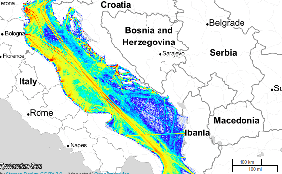
Adriatic traffic density July 2014 - June 2015
Data and Resources
-
Traffic density - Adriatic Sea 2014-2015
Other
-
PreviewPNG
OtherAddInfo
Additional Info
| Field | Value |
|---|---|
| Partner | |
| Topic category | Maritime transport and traffic flows |
| Sub category | |
| Resource language | English |
| Domain area | Adriatic Sea |
| Owner | Balmas,CNR-ISMAR |
| Provider | ADRIPLAN |
| Data portal | ADRIPLAN |
| Presentation form | Map (map represented in raster or vector form) |
| Spatial representation | |
| Coordinate reference system | |
| Web services |
|
| Temporal extent | 2014-07-01 |
| 2015-06-01 | |
| Data accessibility | Data freely accessible |
| Validation level | Official data |
| Additional information | Data are visible in the BALMAS GIS portal: http://www.balmas.eu/balmas-tools/balmas-gis In order to get full access to the application including data download, please contact the BALMAS GIS administration at the following e-mail addresses: balmas@izvrs.si gasper.zupancic@izvrs.si Suggested citation: Project BALMAS, "Marine traffic density (MTD) Years 2014-2015", BALMAS GIS http://www.balmas.eu/balmas-tools/balmas-gis |
| Relevance for testing | |
| Relevance for modules | |
| Metadata completeness | Complete |
| Notes | |
| Import preferences |